Watch out for wind-drifted snow in the couloirs and on leeward slopes and wet snow on sunlit slopes!
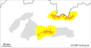
In the High, Western and Low Tatras, due to snowfall and very strong winds, an CONSIDERABLE avalanche danger has been created, level 3. Avalanche release is possible on steep slopes with only a small additional load. Moderate spontaneous avalanches from new snow on sunlit slopes are also possible
Snowpack
Between 20 and 30 cm of new snow fell on Thursday and Friday. However, it was blown by very strong winds (Friday) to leeward places of mainly southern orientations. The wind-blown snow creates unstable snow slabs, pillows and drifts. With occasional sunny weather during the day, the new snow on the southern slopes will become wet and small to medium-sized spontaneous avalanches of wet snow will occur.
Tendency
Persistent.
Danger level
treeline
Avalanche Problem
Wind slab
Treeline
Wet snow
Treeline
Watch out for more new, wind-blown snow on steep slopes and wet snow on sunlit slopes!
Due to intense snowfall (1-2 days) and strong winds, a moderate avalanche danger, 2nd degree, was created in the highest altitudes of the Fatras and the eastern part of the Low Tatras. Avalanche release is possible on steep slopes, especially at higher additional loads. Occasionally, smaller spontaneous avalanches from new wet snow are possible.
Snowpack
Between 10 and 20 cm of new snow fell on Thursday and Friday. The new snow is transported by strong winds (Friday) to the leeward slopes, into couloirs and under saddles, mainly in the south, southeast and southwest orientations, where it created unstable snow slabs, pillows and overhangs. On south-facing, sunlit slopes the snow softens during the day and can form small spontaneous avalanches of wet snow,