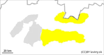
In the Fatras, rain is expected throughout the mountains. The snow will therefore become wet and heavy. In the northern sectors, where powder snow has been maintained, the strength in the snow cover is expected to decrease and small and medium-sized avalanches are likely to fall.
Snowpack
The snow cover is mainly on the southern orientations, packed and blown into a snow slab. In the northern sector, on the other hand, the powder snow will become wetter and heavier. In the forest zone, the snow will be wet and gradually decrease in height.
Tendency
Due to warming and rain rising.
Danger level
2000m
Avalanche Problem
Wet snow
2000m
Wind slab
1800m
Watch out for avalanches from warming and windblown slabs.
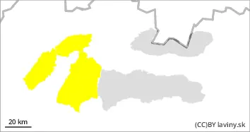
Due to warming temperatures and rain, the avalanche danger is increasing, especially in places where powder snow has been present in the previous days. This will gradually become heavier and small and medium-sized avalanches will form. This is mainly the northern sector up to 2000m above sea level. At the highest altitudes, wind-whipped slabs and pillows will form due to strong southerly winds.
Snowpack
The snow surface on the southern orientations is mainly wind-beaten slabs, which have gradually stabilised due to subsidence. On the other hand, in the northern orientations the powder snow will gradually become wetter and heavier due to warming and rain. The 0°C isotherm is around 1800-2000m above sea level. Above this threshold, snowfall with strong winds is expected in the highest altitudes of the Tatras.